Saturday, August 13, 2011

Day 5: Maizal/Mina Victoria to Yanama

I had a miserable night last night. The tent was on a slope and I kept sliding down until my feet smashed against the side of the tent. To add to the fun, there was a donkey just outside of my tent (I actually bumped into it through the tent) chomping away on grass right by my head. It triggered dreams of the donkey chewing out the tent stakes and the tent sliding/flying/tumbling down the side of the mountain. Needless to say, I didn't sleep well!

We were now back on our regular schedule. We spent the first 1.5 hours climbing uphill through mud, with only a few spots of "dry" ground. Luckily there were enough rocks on the trail to hop between, so we didn't sink ankle deep (or deeper) into the mud. It was physically and mentally draining making that climb (or maybe I was just tired from the flying tent donkey dreams!)

On the bright side, the water contributed to a beautiful lush landscape filled with gold and purple flowers.

After about 1.5 hours, the mud finally gave way to drier ground. We passed several "caves" that were really mining tunnels. Arturo claimed that several passed all the way through the mountain (then why were we hiking OVER the mountain?)
At the time, I didn't realize that this pose made me look like I was squatting to take a crap. That dark "stain" on my right leg is MUD! Really.... it is.

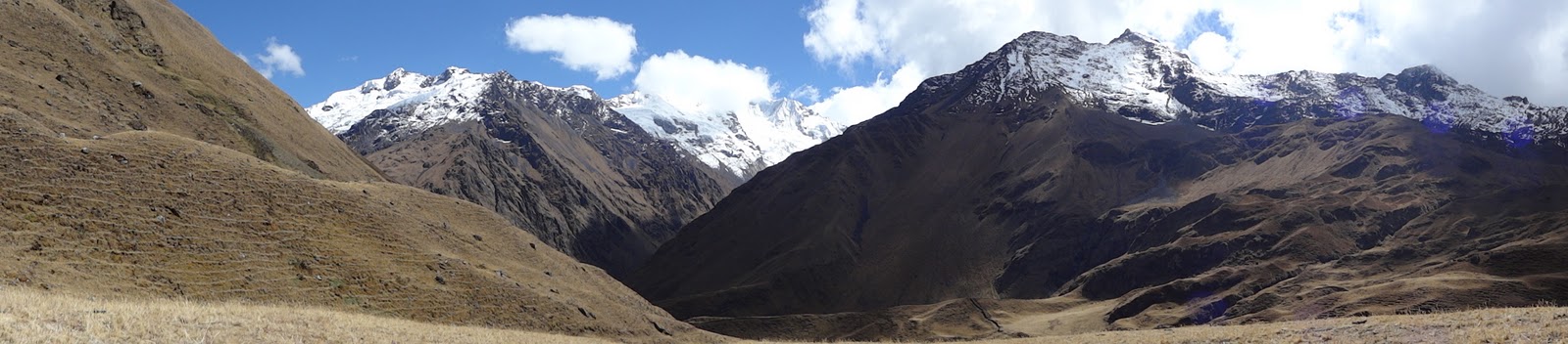
For the next 2.5 hours, we continued to climb towards the Yanama Pass (also called Abra Victoria). Part of the trail closest to the pass was an old paved Inca road. Walking on this section made me glad that I didn't take the Inca trail, since the pavement was harder underfoot than the trails (although a welcome change to the mud earlier in the day).

After a total of about 4 hours of hiking, we finally reached the pass at an elevation of 4130 m / 13,546'.

Because of the elevation, Vilmar and the emergency horse (with very little cargo) stayed with us. Luckily, nobody needed to use it. Although, there was a group of hikers behind us with a very sick Australian who really could have used the horse.

Then we did what we did best .... napped! It was a bit cold and windy at the pass, but the rocks were nice and warm. So we napped on them while waiting for lunch.
We then enjoyed a delicious lunch at the top of the pass.
During lunch, a condor flew over us.

After lunch, we took another nap as our mule caravan headed toward the campsite.

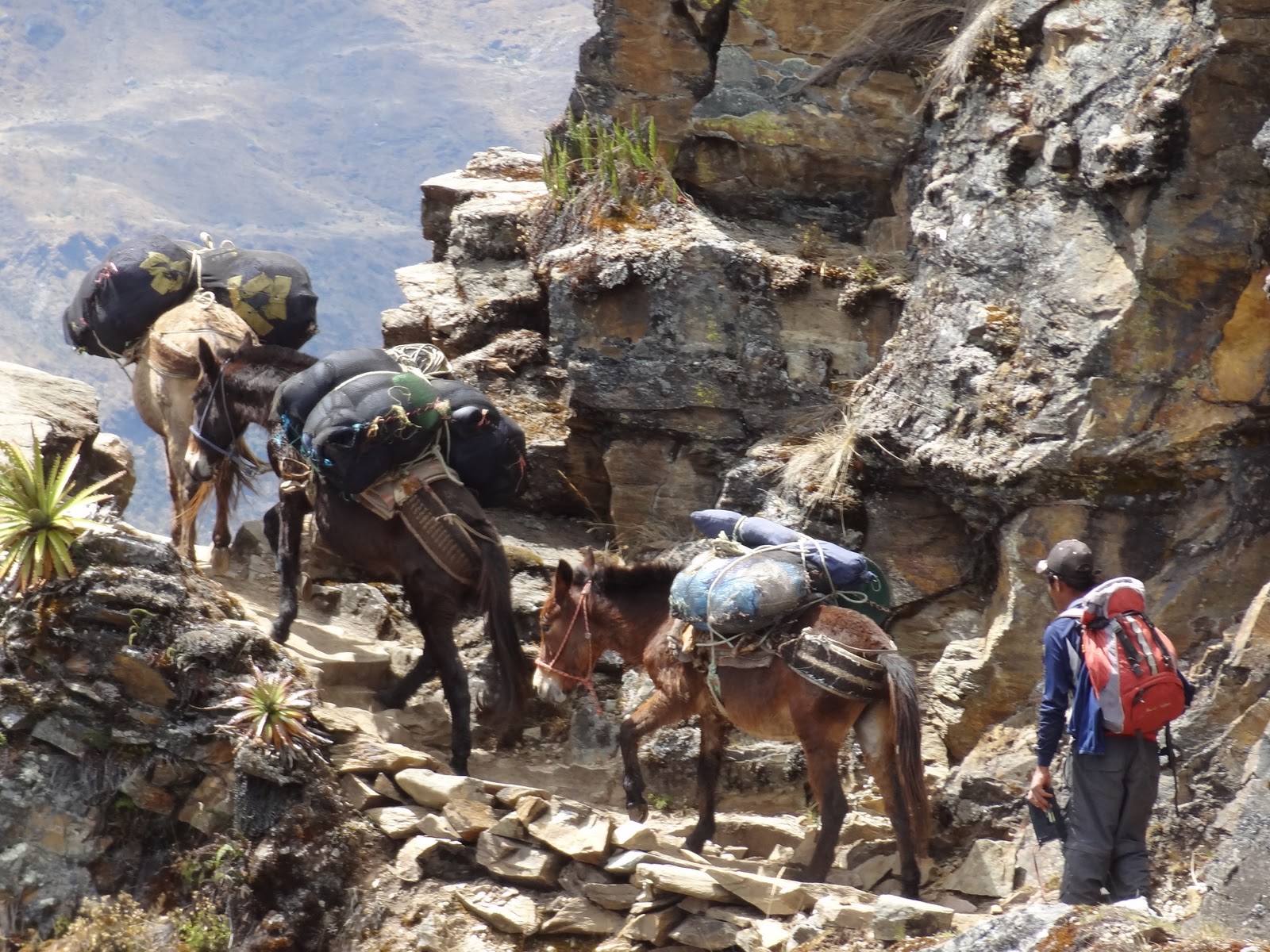
The trail hugged the side of the mountain with steep dropoffs. In some places it was very narrow (and a bit scary) but the views were amazing.

On the way down, we explored a few more mines and then finally caught a glimpse of the village of Yanama, where we would be spending the night.
After about 2.5 hours of hiking from the pass, we finally arrived in Yanama. One of our horsemen lived in the village, so Herbert, our cook, used the horseman's house to prepare our dinner.

We arrived at the campsite a couple of hours before sunset to find our tents set up for us.

While some of the others took a nap, I washed some clothes, took an icy cold shower, then enjoyed hooping in a big grassy field before other groups of hikers arrived to share the campsite.

For dinner, Herbert made us deep fried cuy (Guinea pig), along with deep fried yucca root, pasta, and a plate of beets, carrots and green beans.
I took a piece of the Guinea pig, thinking I would just take one polite bite. I chomped every bit of meat off the bones! It was delicious (or I was really hungry!!)

It was really cold at this elevation and I was thankful for my warm sleeping bag, layers of fleece, and the chemical hand warmers my friend Pamela gave me for my birthday. I put one in the little pouch at the foot of my sleeping bag, and the other in my fleece pocket, and stayed warm and toasty all night.

Trail Stats:
Distance: 12 km / 7.5 mi
Duration: 6.5 hrs
Elevation Gain: 600 m / 1948'
Elevation Loss: 550 m / 1804'

Camping at 4100 m / 13451'

Day 6: Yanama to Colpapampa


The hand warmers, a few layers of fleece, and my sleeping bag kept me nice and toasty warm all night, but it was COLD  and windy in the morning when we first started hiking. I'm wearing a couple layers of fleece, my down jacket, and my windbreaker.


The hike from the campground started off as a gentle incline, through villages and farms. We saw several students walking to school, carrying 2-3 pieces of wood for the fire used to cook their breakfast and lunch.

After about 45 minutes, we were leaving the pastures and getting into higher and dryer grounds.


There were still lots of springs and waterfalls along the way. We had approx. 25 water crossings along the way.

After steadily climbing for about 3.5 hours, we finally reached a grassy meadow where we stopped for a rest (nap) and a snack.  The snow capped peaks of Pumasillo were to our north.


and the peaks of Padreyoc were to the south. We will be heading over the pass about 2/3 from the left in the picture (under the biggest blue section of sky).


Because of the altitude and the possibility of somebody getting ill, Vilmar and the emergency horse walked with us instead of the rest of the crew. I think the rest of the crew would be jealous of they saw him resting with us!


After the break, we tackled the final climb to the pass.

Here we are getting closer.


Arturo instructed us to wait at the rocky section just below the pass until the rest of the group arrived. It was really cold and windy but the rocks provided a bit of a wind break. When Emilie and I got there, we saw this family and their mules taking a break before heading down (they were going the opposite direction as us).


We are almost all together.


Brad finally caught up.
Yeah, we all made it to the top (4850 m / 15908'), without the emergency horse! Unfortunately, the clouds blocked the view of the Santa Teresa valley below. We snapped a few pictures, then headed down the other side to get out of the wind.


Even as we started our descent, we still couldn't see the valley below us.

We also ran into another mule train on the way down.


Finally we got our first clear view of the valley below. Now we just have to get there to set up camp.

Between the more gradual slope of the path and Ben and Karryn taking tons of pictures, I wasn't hiking downhill alone at the back of the pack for a change. After about 2 hours of hiking from the pass, we stopped for a lunch break.


Then we started hiking again. The bottom of the valley is getting closer. The light line on the right side of the picture is the trail we were on.

After hiking another 1.5 hours after lunch, we crossed this river, then reached a gravel road that went through several villages and would lead to our campsite.

There were a few shortcuts through the fields that bypassed some of the long switchbacks on this road. About half of them were very narrow and steep, so I evaluated each one. Instead of going really slow on the steep ones, I took the longer route on the road, but at least I could go at a faster pace and not worry about twising an ankle or my knee. On the more gradual ones, I took the short cut.

I arrived at camp about 10 minutes after the group, and just before dusk.At this point, we shared a campsite with lots of other groups - all the groups doing the Salkantay trek. The campsite was a lot noisier, with other groups, villagers (a baby crying all night), and livestock. Between the tent on a slope and a pig grunting outside my tent all night, I didn't sleep well. I woke up to the sounds of what sounded like a pig and rooster fighting to the death. Not a good sound!

Trail Stats:
Distance: 21 km / 13 miles
Duration: 9 hours
Elevation gain: 700 m / 2296'
Elevation loss: 1900 m / 6232 '

Camping elevation: 2682 m / 8800'

Day 7: Colpapampa to La Playa to Santa Teresa

 Since we weren't used to sharing the trails with others, we got an early jump on the day to avoid the crowds.

After a brief walk down the road, we veered off onto a trail that led us into a highland "jungle" - often called the eyebrow of the jungle.
This trail followed the road, with a river between us and the road.
Periodically, we would see a plley bridge that allowed the villagers to cross the river.

Some of the plants along the trail...


The trail was mostly dry, with the occasional muddy spot or waterfall, and had gradual ups and downs.
After about two and a half hours, we passed through a village where we could buy snacks. We saw these turkeys on the outskirts of the village.

After about 2 more hours of hiking, we were met by a car and driven the last 2-3km down the road to La Playa, where we had a delicious lunch.


After lunch, we said goodbye to our horsemen and were then driven to our last campsite in Santa Teresa. After quickly setting up our tents, we took a taxi to the Santa Teresa hot springs. 

The hot springs had just been rebuilt after a devastating flood the prior year. I found the warmest spot and let the hot water soothe my aching muscles. It felt wonderful! After about 2 hours of soaking, we hired a car to take us back to the campsite.

After having tea and a light meal at the campsite

We headed into town to explore a bit, before heading back to the campsite for the night.


Trail Stats:
Distance: 11 km / 6.8 miles
Duration: 4 hours
Elevation gain: 40 m / 131'
Elevation loss: 810 m / 2657 '

Camping elevation: 1550 m / 5085'


Day 8: Santa Teresa to Aguas Calientes


Today was the last day of actual trekking. 


We walked to the Hydroelectric station.


Then we walked along the train tracks to Aqua Calientes, where we spent the night in a hotel. 


Today we walked 10.5 miles in 5.5 hours, with little elevation change.